
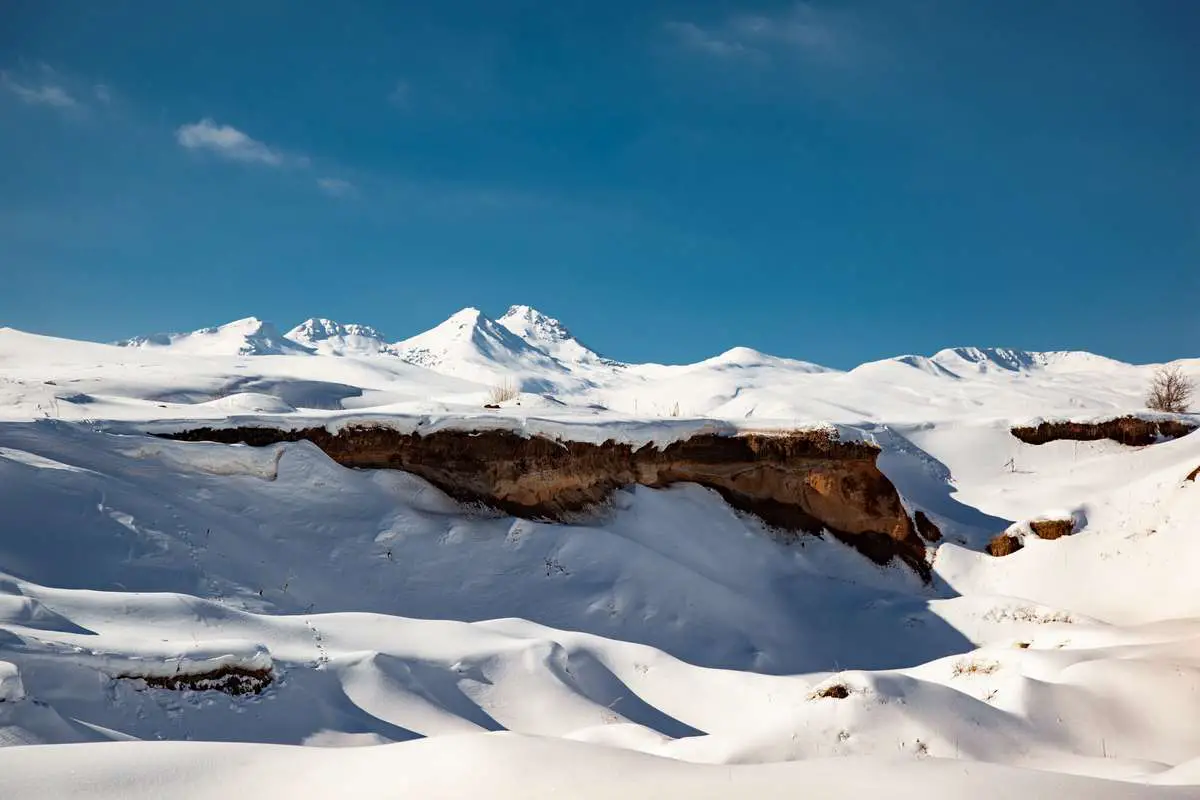
Not far from Yerevan there is a four-peaked giant, proudly sitting between heaven and earth, sometimes covered with a mysterious fog, sometimes open-faced, illuminated by the sun and more often with a crown of clouds on its “heads”.
It greets everyone from afar and calls those, who can hear his silence. Aragats is the mountain, the highest point of the Republic of Armenia.
The Four-Peaked Giant
If you are in Armenia and want to stay cool even in the hottest day of the year, or to see amazing, fairy-tale scenes, to meet all four seasons of the year at the same place, to feel fear and joy at the same time or just be on the highest point of the country, then you should definitely climb Aragats.
Being a wonderful place for acclimatization and training, it is one of the favorite mountains of Armenian mountaineers and hikers.
In the list of the highest mountains of the Armenian Highland, Aragats has the fourth place after Ararat (5165m), Sabalan (4811m) and Jilo (4135). Occupying an area of about 4000 km², it is surrounded by Kasagh River on the east, Akhurian River on the west, Ararat plain on the south, and Shirak plain on the north.
Aragats was one of the largest volcanoes in the world. There is a saying, that it had one summit even higher than Everest before it erupted in the early past and a huge crater at a depth of 400 m and 3 km in diameter arose in the middle, the remains of the ruined walls of which now form the four peaks of the mountain.
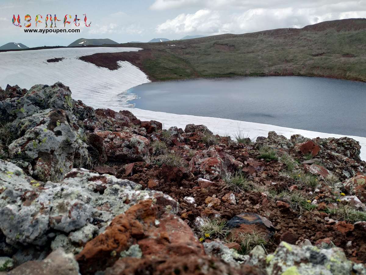
There are many freezing springs in the crater formed from snowmelt, with immortally delicious water. The Gegharot River, a tributary of the Kasakh, originates here.
Aragats Mountain Four Summit Names
All four summits of Aragats have their names, simple names related to their geographic position։ Southern, Western, Northern, and Eastern. Each of them has a unique structure, content, and even a character.
How to access the mountains Peak by Peak
The southern peak
Is the lowest one. It has a height of 3887 m. Since it is also the easiest summit, new hikers prefer it before going to the other three. There are two main paths leading to the peak.
One of them is covered with alpine meadow and big stones, the other one is rocky, a little bit difficult, and sometimes even dangerous. Last year a bear was noticed there.
People say it lives under the rocks of the summit. The southern peak is the only one that has a shelter on it and on windy days travelers can hide there and take a rest.
The Eastern peak
Comes next with its 3908 meters and rocky “body”. First, you go by a path laying between the huge stones, but in the middle part, you need to climb. Often the stones break off the rocks during the climb and make the road dangerous.
In case of taking the standard track, you will need to go down into the crater to reach the Eastern peak which means you will feel as if you are the smallest ant in the world. When you go there for the first time you feel like you will never get out of it. Powerful and breathtaking, surrounded with four giants silently watching after your moves, the crater has an unsurpassed, magical, scary beauty.
The third highest peak is the western one
3995 m. It has a crooked road and a slippery surface. You may take ten steps and discover that you have gone forward only for three.
As you have already guessed, the highest summit is the Northern one, 4090.1 m. Almost always you can meet a wind there, wandering around and singing wild songs brought from the depths of time. Covered with small stones and sand, the road is sliding and making the ascent difficult, but the descent is relatively easy.
In some places, you just have to keep your balance and the send will take you down for 2-3 meters with each step.
The Northern summit
has two peaks: false (4080 m) and real. The real one is only 150 meters away from the false peak, but it is very dangerous, since the rocks leading to it are very narrow, surrounded by an abyss from both sides. Only experienced hikers climb it.
How to plan to hike the four Peaks in One Day?
Normally, hikers choose one of the four summits of Aragats and climb it, enjoying the views and resting in the beautiful hugs of the mountain. Nevertheless, there exists a type of crazy people, who climb all the summits in one single day.
It takes approximately 10-12 hours, depending on the person’s strength and the level of readiness. In order to fit in time, one should start hiking from early morning by two options: either have an overnight on Aragats or leave for it at night.
Video Footage of Mount Aragats & Surroundings
Where Does The Name Aragats Come?
According to the Armenian tradition, Aragats originates from the words “Ara” («Արա», Ara the Handsome, a legendary Armenian hero) and “gah” («գահ», which means “throne”), and together they mean “Ara’s throne”.
Aragats was mentioned by the early medieval historian Movses Khorenatsi.
In his work “History of Armenia,” he claims that the mountain is named after Aramanyak, the son of Hayk, the legendary father of the Armenian people. Aramanyak used to call his possessions «ոտնԱրագածոյ» (otn Aragats’oy), which means “the foot of Aragats” and in modern Armenian, it sounds like “Aragatsotn”.
Kari Lake and the Meteorological Station
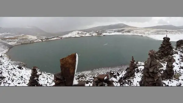
There are two things without which it is impossible to imagine Aragats։ Kari Lake and the meteorological station.
Kari Lake (“Stone Lake”) is situated at an altitude of 3200 meters above sea level on Aragats mountain and considered as a starting point for hikers.
It is also a good camping zone and during the tourist season, you may see many colorful tents set up around the lake. It originates from ice formations and gives birth to the Arkashen River from the western shore. In some places, the lake is 8 meters deep.
The meteorological station is situated a little above the lake. It is a real salvation for those, who get into trouble while trying to climb Aragats. One can always run from the mountain cold, bad weather, and find a warm corner with a cup of hot tea there.
Friendly workers of the station are always ready to share with you everything they have and to help with anything they can. One can even have an overnight there.
Fun Fact about Mount Aragats
According to one of the legends, Gregory the Illuminator, who converted Armenia into Christianity in the early 4th century, used to pray on the peak of Aragats mountain. At nighttime an icon-lamp shone to give light for him, the lamp hanging from heaven using no rope. Some say that the icon-lamp is still there, but only the worthy ones can see it.
Another legend tells, that there was a time when Aragats and Masis were loving sisters. One day they are having an argument about their height. One says, “I am the best, the highest”, the other says, “I am higher than you, higher and more beautiful”. Maruta Mount watches them, reaches, and tries to reconcile the sisters. But he fails.
Then he curses them: “Let Masis and Aragats be separated from each other in such a way that they will never meet again”. In his turn, Masis curses Aragats so that sorrow never leaves his heart and tears never leave his eyes. Aragats curses Masis so that he dries up with grief, no one rises to his feet in the world, no sacrifice is slaughtered on him.
Must Know Facts About Mountain Aragats
- On May 28, 2005, a unity dance was organized around Aragats. It was dedicated to the Day of the First Republic of Armenia. More than 250 000 people took part in it, dancing hand in hand on the perimeter of 163 kilometers.
- The mountain has an eternal snow cover of about 6 km. It also has several glaciers, the largest of which (1.5 km in area) is in a crater.
- Except for Kari Lake, there are many other small lakes on Aragats, which are formed and fed by meltwater. Those are Amberd, Astghonk, Lessing, Umroy lakes, and a couple of others.
- If the weather is good, you can see Ararat with all its beauty and power all the time while climbing Aragats.
- There is a wonderful waterfall of Gegharot on the slope of Aragats, about 3000 meters above the sea level, on the Gegharot tributary of the Kasagh River.
- In late spring and summer, Aragats is covered with different beautiful flowers.
- Winter comes to Armenia through Aragats.
If you like this article and would like to be updated when we publish a new one,
please follow us on Aypoupen Instagram ,
and like our Aypoupen Facebook page
and subscribe to our Aypoupen Youtube channel.